SSBA: Both Official 1:200,000 Map and Thailand’s L7017 Unilateral Map Place Khnar Temple in Cambodia.
 SSBA: Both Official 1:200,000 Map and Thailand’s L7017 Unilateral Map Place Khnar Temple in Cambodia.
A senior official from Cambodia’s State Secretariat of Border Affairs (SSBA) has stated that not only does the official 1:200,000-scale map produced by the Commission for the Delimitation of the Boundary between Indochina and Siam place Khnar Temple within Cambodian territory, but even Thailand’s own unilaterally produced L7017 map confirms that the temple lies inside Cambodia.
Speaking during an interview on TVK, Ith Sotha, Permanent Secretary of State at the SSBA, said the Cambodia–Thailand border is an internationally recognised boundary established in the early 20th century through agreements between French Indochina and Siam.
“I would like to reaffirm once again that the Cambodia–Thailand border is an international boundary established in the early 20th century through boundary delimitation and the placement of 73 boundary markers,” he said.
He said the boundary was determined through conventions, treaties, official maps, boundary pillar records and physical demarcation carried out jointly by French authorities representing Cambodia and Siamese authorities, now Thailand.
Referring to earlier remarks by fellow Ministry of Culture and Fine Arts Secretary of State Sum Map, Sotha said Khnar Temple is situated within Cambodia’s territory and sovereignty, based on the official 1:200,000-scale map produced by the Commission for the Delimitation of the Boundary between Indochina and Siam.
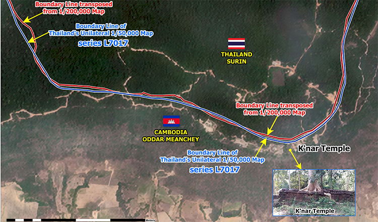
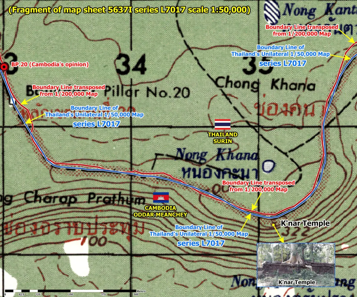
He presented satellite imagery comparing Cambodia’s official boundary line, transferred from the 1:200,000-scale map, with Thailand’s unilaterally produced 1:50,000-scale map, saying both boundary lines place Khnar Temple within Cambodian territory.
“The temple’s location can clearly be seen on this current satellite image. Therefore, both boundary lines—the Cambodian position shown in red and the Thai position shown in blue—indicate that the temple lies within Cambodia’s sovereignty,” he said.
Sotha also referred to Thailand’s L7017 map series, saying the unilaterally produced map likewise places Khnar Temple, Tamone Thom Temple and several other temples within Cambodian territory.
“I would also like to further clarify that the L7017 map, which Thailand produced unilaterally and has used unlawfully, also shows that Khnar Temple, Tamone Thom Temple, and several other temples along the border are located within Cambodian territory,” he said.
Sotha further noted that the Thai military is attempting to redraw the boundary line to incorporate areas that Cambodia says it has illegally occupied.
“Therefore, regardless of the L7017 map used by Thailand, or any other maps that Thailand has produced or drawn unilaterally, those maps have no legal validity or legal effect,” he said.
The 11th-century Khnar Temple, located in the Dangrek Mountain range in Oddar Meanchey province, was illegally occupied by the Thai army in December following the second round of military aggression against Cambodia.
-Khmer Times-