Border officials reiterate: Even Thai maps show occupied temples inside Cambodian territory
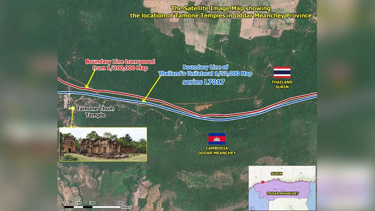 - Both French colonial era-maps and Thailand’s unilaterally drawn ones show that Tamone Thom Temple is located within Cambodia. SSBA
Both official maps from the French colonial era and unrecognised unilaterally drawn Thai maps demonstrate that the Khmer temples which Thai forces occupied near the border are located inside Cambodian territory, noted a senior official at Border Affairs at the State Secretariat of Border Affairs (SSBA).
Speaking to National Television of Cambodia (TVK) today, July 8, Ith Sotha, SSBA permanent secretary of state, said that the Tamone Thom and Khnar temples clearly stand inside Cambodia, no matter what maps are used.
“Referring to the boundary line copied from the 1:200,000 scale map (Sector 4), and the topographic plan — which the French call the “Plan d’Indication Topographique” — as well as the unilateral boundary line on the 1:50,000 scale L7017 map produced by the Royal Thai Survey Department, it is very clearly seen that Tamone Thom Temple is located within Cambodian territory,” he said, during the interview.
Last week, he clarified that Khnar Temple in Oddar Meanchey province is also inside Cambodia.
He added that satellite image clearly shows they are in Cambodia, consistent with both maps.
“I should mention that previously, when I showed the boundary lines and the location of Khnar Temple using satellite imagery, some Thai opinions suggested the presentation was not ideal, arguing the images were too small. However, I want to clarify that satellite images can be zoomed in and out, just like in Google Maps.
“When we zoom in, we can see the temple very clearly. On this map, there is a red line, which is the line we copied from the 1:200,000 scale map, and a blue line, which is the line the Thai side drew unilaterally. Even according to the Thai map, Ta Mone Thom Temple is entirely within Khmer territory,” he said, explaining the map.
“Looking at the map extract from the 1:50,000 L7017 map produced by the Royal Thai Survey Department, Tamone Thom Temple is shown to be within Cambodian land. If we look at the blue line on this Thai map, Tamone Thom is entirely on our side,” he added.
According to Sotha, the plan d’Indication Topographique or Topographic Indication Plan, is a geographical layout annexed to the measurement records of the Indochina-Siam Boundary Delimitation Commission from 1908.
“I want to emphasise that even on the L7017 map — which Thailand drew unilaterally and has been using unlawfully — the map still shows that Tamone Thom Temple is in Khmer territory,” he said.
“Even if they attempt to redraw new boundary lines to incorporate areas they are illegally occupying into Thai territory, those maps cannot be considered valid or have any legal effect,” he stated.
-Phnom Penh Post-